ENGLISH
 ESPAÑOL
 DUTCH
DUTCH FRANÇAIS
 ITALIANO
 РУССКИЙ
 TÜRKÇE
Nautical Mile Distances in Turkey: A Practical Yacht Route Planning Guide
How far is Bodrum from Kos by sea? Can you comfortably cruise from Fethiye to Kekova in one day? And what does a 49-nautical-mile passage actually mean in hours? This guide turns a dense distance chart into clear, useful information for planning a yacht holiday along the Turkish coast and the nearby Greek islands.
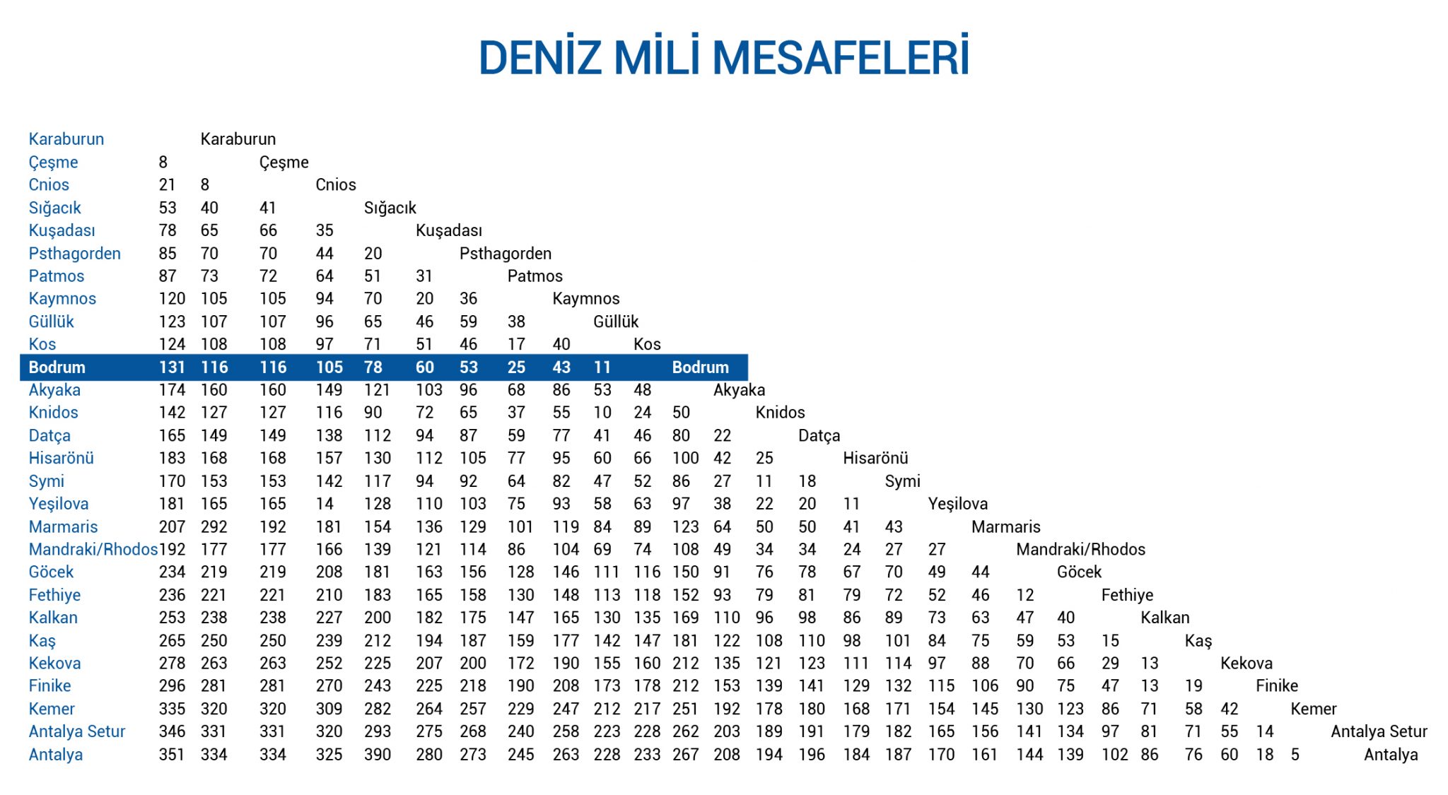
A blue cruise rarely feels like travelling from point A to point B. One morning begins in a quiet bay, lunch is served after a short swim stop, and the yacht may anchor somewhere completely different before sunset. Yet behind that relaxed rhythm is careful route planning. Distance affects how long the engines run, how much fuel may be used, when guests can swim and whether an itinerary still feels like a holiday rather than a delivery trip.
The tables below are designed for travellers comparing gulet charter routes, motor yacht itineraries and cross-border cruises. They are not a substitute for nautical charts, official navigation systems or the captain’s judgement.
What Is a Nautical Mile?
A nautical mile is the standard distance unit used at sea and in aviation. One nautical mile is exactly 1.852 kilometres, or approximately 1.151 land miles. Unlike the kilometre, it is linked to the geography of the Earth, which makes it practical for navigation using latitude and longitude.
Boat speed is normally stated in knots. A yacht travelling at 10 knots covers 10 nautical miles in one hour under ideal conditions. Therefore, a 40-nautical-mile passage would take four hours in theory.
The important word is estimated. A cruising speed shown in a yacht specification is not a promise that the vessel will maintain that figure throughout the route. Wind, waves, current, harbour manoeuvres, traffic and guest comfort can all influence speed.
Short Sea Distances for Easy Cruising Days
Short legs are often the most enjoyable part of a private yacht holiday. They leave more time for breakfast at anchor, swimming, paddleboarding and an unhurried lunch. The following distances are especially useful when building a relaxed itinerary.
| Route | Distance | Approx. kilometres | Why it works |
|---|---|---|---|
| Karaburun – Cesme | 8 NM | 14.8 km | A compact Aegean coastal leg |
| Cesme – Chios | 8 NM | 14.8 km | A short international crossing, subject to formalities |
| Bodrum – Kos | 11 NM | 20.4 km | A popular Turkey–Greece connection |
| Datca – Symi | 11 NM | 20.4 km | A convenient Dodecanese crossing |
| Fethiye – Gocek | 12 NM | 22.2 km | Ideal for a gentle first or final day |
| Kas – Kekova | 13 NM | 24.1 km | A scenic Lycian coast passage |
| Kalkan – Kas | 15 NM | 27.8 km | A manageable coastal cruising day |
| Kekova – Finike | 19 NM | 35.2 km | A practical eastern continuation |
How far is Bodrum from Kos by yacht?
The chart places Bodrum and Kos approximately 11 nautical miles apart, equal to about 20.4 kilometres. At a theoretical average of 10 knots, the sea passage itself is around 1 hour and 6 minutes. International departure and arrival procedures, waiting time and the yacht’s actual marina can make the full journey longer. Guests interested in combining both coastlines can explore our Greece yacht charter information before choosing a route.
How far is Fethiye from Gocek by sea?
Fethiye and Gocek are shown as approximately 12 nautical miles, or 22.2 kilometres, apart. Their proximity makes them flexible embarkation points. The real distance changes with the exact marina, anchorage and channel used, but the passage is usually well suited to a relaxed cruising day. See our Fethiye yacht charter options for yachts based in the region.
How far is Kas from Kekova by sea?
The approximate Kas–Kekova distance is 13 nautical miles, or 24.1 kilometres. It is short on paper, but the appeal lies in slowing down: the bays, the island of Kekova and the archaeological landscape reward an itinerary with time for stops. Our Fethiye to Kekova itinerary shows how this region can fit into a seven-night cruise.
Nautical Mile Distances from Bodrum
Bodrum is one of the most versatile yacht charter bases in the southern Aegean. Guests can stay close to the peninsula, turn east towards the Gulf of Gokova and Datca, or plan an international itinerary towards Kos and the Dodecanese. For regional inspiration, visit our Bodrum Blue Cruise guide.
| From Bodrum to | Nautical miles | Approx. kilometres | Route character |
|---|---|---|---|
| Kos | 11 NM | 20.4 km | Short international crossing |
| Knidos | 24 NM | 44.4 km | Historic headland and open-water section |
| Kalymnos | 25 NM | 46.3 km | Dodecanese island connection |
| Gulluk | 43 NM | 79.6 km | Gulf and coastal passage |
| Datca | 46 NM | 85.2 km | Longer Aegean cruising leg |
| Akyaka | 48 NM | 88.9 km | Deep into the Gulf of Gokova |
| Symi | 52 NM | 96.3 km | International island route |
| Marmaris | 89 NM | 164.8 km | Better divided into scenic stages |
| Gocek | 116 NM | 214.8 km | A substantial repositioning passage |
| Fethiye | 118 NM | 218.5 km | Usually planned across several stops |
The difference between an 11 NM crossing to Kos and a 118 NM route to Fethiye is not merely seven or eight additional hours at sea. Longer routes also require decisions about overnight anchorages, weather windows, refuelling, guest comfort and how much of the holiday should be spent underway. A week-long Blue Cruise in Turkey is normally more rewarding when the route includes manageable legs rather than one long dash.
Datca, Symi, Marmaris and Rhodes Distances
This part of the coast is loved for its variety. One itinerary can move from Datca’s relaxed waterfront to ancient Knidos, the sheltered bays of Hisaronu, the neoclassical harbour of Symi and Rhodes. Border procedures must be built into any Turkey–Greece plan.
| Route | Distance | Approx. kilometres | Planning note |
|---|---|---|---|
| Datca – Symi | 11 NM | 20.4 km | Short distance, international formalities required |
| Hisaronu – Symi | 18 NM | 33.3 km | Comfortable distance in suitable conditions |
| Datca – Knidos | 22 NM | 40.7 km | Allow time to visit the archaeological site |
| Symi – Rhodes Mandraki | 24 NM | 44.4 km | Island-to-island Dodecanese passage |
| Marmaris – Rhodes Mandraki | 27 NM | 50.0 km | Popular cross-border connection |
| Marmaris – Gocek | 49 NM | 90.7 km | A longer day or a route split with stops |
| Marmaris – Datca | 50 NM | 92.6 km | Best enjoyed as part of a wider itinerary |
Gocek, Fethiye, Kalkan, Kas and Kekova Distances
The Lycian coast brings together pine-covered bays, dramatic mountains and archaeological sites reached beautifully from the sea. Gocek and Fethiye offer access to sheltered cruising grounds, while Kalkan, Kas and Kekova create a route with a more adventurous coastal character.
| Route | Distance | Approx. kilometres | Suggested approach |
|---|---|---|---|
| Fethiye – Gocek | 12 NM | 22.2 km | Easy first or final cruising day |
| Kas – Kekova | 13 NM | 24.1 km | Keep time for bays and historic sites |
| Kalkan – Kas | 15 NM | 27.8 km | Compact coastal leg |
| Kalkan – Kekova | 29 NM | 53.7 km | Moderate passage with optional stops |
| Fethiye – Kalkan | 40 NM | 74.1 km | Plan around weather and guest comfort |
| Gocek – Kalkan | 47 NM | 87.0 km | Longer open-coast cruising day |
| Fethiye – Kekova | 66 NM | 122.2 km | More enjoyable when divided into stages |
| Gocek – Kekova | 70 NM | 129.6 km | Suitable for a multi-day route |
Although Fethiye and Kekova are approximately 66 nautical miles apart in the chart, a good holiday itinerary does not normally treat them as a single uninterrupted transfer. Oludeniz, Gemiler Island, Kalkan and Kas can become meaningful stops. That is why a yacht charter route should be judged by the experience between the ports, not only by the total mileage.
How Long Do These Yacht Passages Take?
The following table converts selected distances into theoretical cruising times at 8, 10 and 12 knots. Eight knots is a useful reference for many displacement-style gulets and trawlers, while faster yachts may cruise above 12 knots. Nevertheless, the captain may deliberately reduce speed for comfort, safety or fuel efficiency.
| Route | Distance | At 8 knots | At 10 knots | At 12 knots |
|---|---|---|---|---|
| Bodrum – Kos | 11 NM | 1 hr 23 min | 1 hr 06 min | 55 min |
| Fethiye – Gocek | 12 NM | 1 hr 30 min | 1 hr 12 min | 1 hr |
| Kas – Kekova | 13 NM | 1 hr 38 min | 1 hr 18 min | 1 hr 05 min |
| Kalkan – Kas | 15 NM | 1 hr 53 min | 1 hr 30 min | 1 hr 15 min |
| Datca – Knidos | 22 NM | 2 hr 45 min | 2 hr 12 min | 1 hr 50 min |
| Marmaris – Rhodes | 27 NM | 3 hr 23 min | 2 hr 42 min | 2 hr 15 min |
| Fethiye – Kalkan | 40 NM | 5 hr | 4 hr | 3 hr 20 min |
| Marmaris – Gocek | 49 NM | 6 hr 08 min | 4 hr 54 min | 4 hr 05 min |
These estimates describe movement through the water only. They do not include leaving the berth, harbour speed limits, swimming stops, anchoring, entering a new marina or completing customs procedures. A planned four-hour leg can easily occupy a larger part of the day.
How Nautical Miles Affect Fuel and Charter Cost
More distance usually means more engine hours, but nautical miles alone cannot produce an accurate fuel quotation. Consumption depends on the yacht’s engines, hull, load, sea conditions and operating speed. A motor yacht may cover the same route faster than a gulet, yet use considerably more fuel per hour. A displacement yacht may take longer but travel more economically.
Generators, air conditioning, tenders and motorised water toys can add to consumption even while the yacht is anchored. The way fuel is charged also varies by charter agreement: it may be included up to a defined cruising allowance, charged according to actual use or paid from an Advance Provisioning Allowance. Our yacht charter prices guide explains the broader cost structure.
Does cruising faster always save time?
Not in the way guests sometimes expect. Increasing speed may shorten the theoretical passage, but it can sharply increase consumption and may reduce comfort in choppy seas. On a private charter, the better question is often not “How fast can we get there?” but “Which speed gives us the most comfortable day without wasting fuel?” Your captain can answer that for the yacht and current conditions.
Which yacht type suits a longer route?
There is no single winner. A crewed gulet charter suits guests who value space, outdoor living and a traditional Blue Cruise rhythm. A motor yacht charter may appeal when covering more ground is important. A trawler charter can offer a balance of comfort, range and fuel-conscious displacement cruising.
Why the Actual Route May Differ from a Distance Chart
A distance table is best used for comparison. It can show that Bodrum–Kos is a short crossing while Bodrum–Fethiye is a major passage, or that Fethiye–Kekova deserves several days if guests want to enjoy the coast. It should never be used as a standalone navigation source.
How to Build a Comfortable One-Week Yacht Itinerary
- Choose the right embarkation port. Start near the places you most want to see. This reduces unnecessary transfer mileage on the first and final days.
- Decide whether the cruise is domestic or international. Adding Greek islands changes paperwork, port planning and potentially the charter cost.
- Balance short and longer legs. A few hours underway can be enjoyable; repeating long passages every day may become tiring.
- Protect time for the experience. Include swimming, meals, shore visits and quiet afternoons instead of treating every day as a transit day.
- Match the route to the yacht. Cruising speed, range, fuel policy and guest capacity matter as much as the map.
- Keep one element flexible. Weather may make a different bay or port more comfortable. Flexibility is part of good seamanship.
- Confirm the plan with the captain. The captain turns your preferences into a safe, realistic itinerary and may revise it during the cruise.
If this is your first charter, tell the team what you enjoy rather than trying to design every nautical mile yourself. Families may prefer sheltered bays and short legs; couples may want quiet anchorages; active groups may prioritise islands, water sports and more varied ports. The right plan begins with your travel style.
Frequently Asked Questions About Nautical Mile Distances
How many kilometres are in one nautical mile?
One nautical mile equals exactly 1.852 kilometres. To convert nautical miles to kilometres, multiply the distance by 1.852.
What is the difference between a knot and a nautical mile?
A nautical mile measures distance. A knot measures speed. One knot means travelling one nautical mile per hour.
How many nautical miles is Bodrum from Kos?
The chart shows approximately 11 nautical miles between Bodrum and Kos, equal to about 20.4 kilometres. Exact marina positions and the navigable course can change the travelled distance.
How many nautical miles is Fethiye from Gocek?
The approximate chart distance is 12 nautical miles, or 22.2 kilometres. It is a useful reference for planning, not a substitute for the captain’s route.
How long does it take to sail from Kas to Kekova?
At a theoretical average speed of 10 knots, the 13-nautical-mile distance takes about 1 hour and 18 minutes. Weather, the yacht, anchorages and stops can increase the total time.
Can Fethiye and Kekova be included in a one-week charter?
Yes. The chart gives an approximate direct distance of 66 nautical miles, but a seven-night itinerary is normally divided into attractive stages such as Gemiler, Kalkan and Kas. Final feasibility depends on the yacht, embarkation arrangements and conditions.
Are nautical distance tables exact?
No. They are approximate planning references. The actual navigable distance depends on precise departure and arrival points, safe routing, weather, restrictions and planned stops.
Does a longer route always make a charter more expensive?
It often increases engine hours and fuel use, but the total price also depends on yacht type, fuel policy, marina fees, international formalities, food and other charter terms.
Let Us Turn the Miles into the Right Route
A good charter itinerary is measured in memorable mornings and unhurried bays, not only in nautical miles. Tell us your preferred dates, group size, embarkation region and must-see destinations. The Platin Yachting team can recommend a suitable yacht and help shape a realistic route around your priorities.